Manual / Drill data
Drill data
Once collar and survey files are in, ES3D desurveys every hole and renders traces, assay intervals and lithology in real coordinates. Everything here styles live and is scoped by the same query filters the models honour.
The drilling layers
- Traces — desurveyed 3D polylines with a Trace width slider and colour control.
- Collars — sphere markers with Collar size (metres) and Collar colour; optional Collar labels show each hole ID.
- Assay intervals — coloured downhole intervals. Pick the Element, Colormap, ramp Min/Max, Bins and Theme; Size by grade scales disc diameter with grade, and Hide below grade is a display cutoff.
- Lithology — pick the Lithology column, set the Litho radius, and edit per-code colours, categories and groups in the litho editor.
- Planned holes — imported separately (see Importing data) and always visibly distinct: steel-blue dashed traces, diamond collars, and a Planned label on every collar. Planned drilling can never be mistaken for results.
X-ray keeps drilling visible through solids in front of it, drawn as a muted tint so the occlusion is still honest.
Downhole bar logs
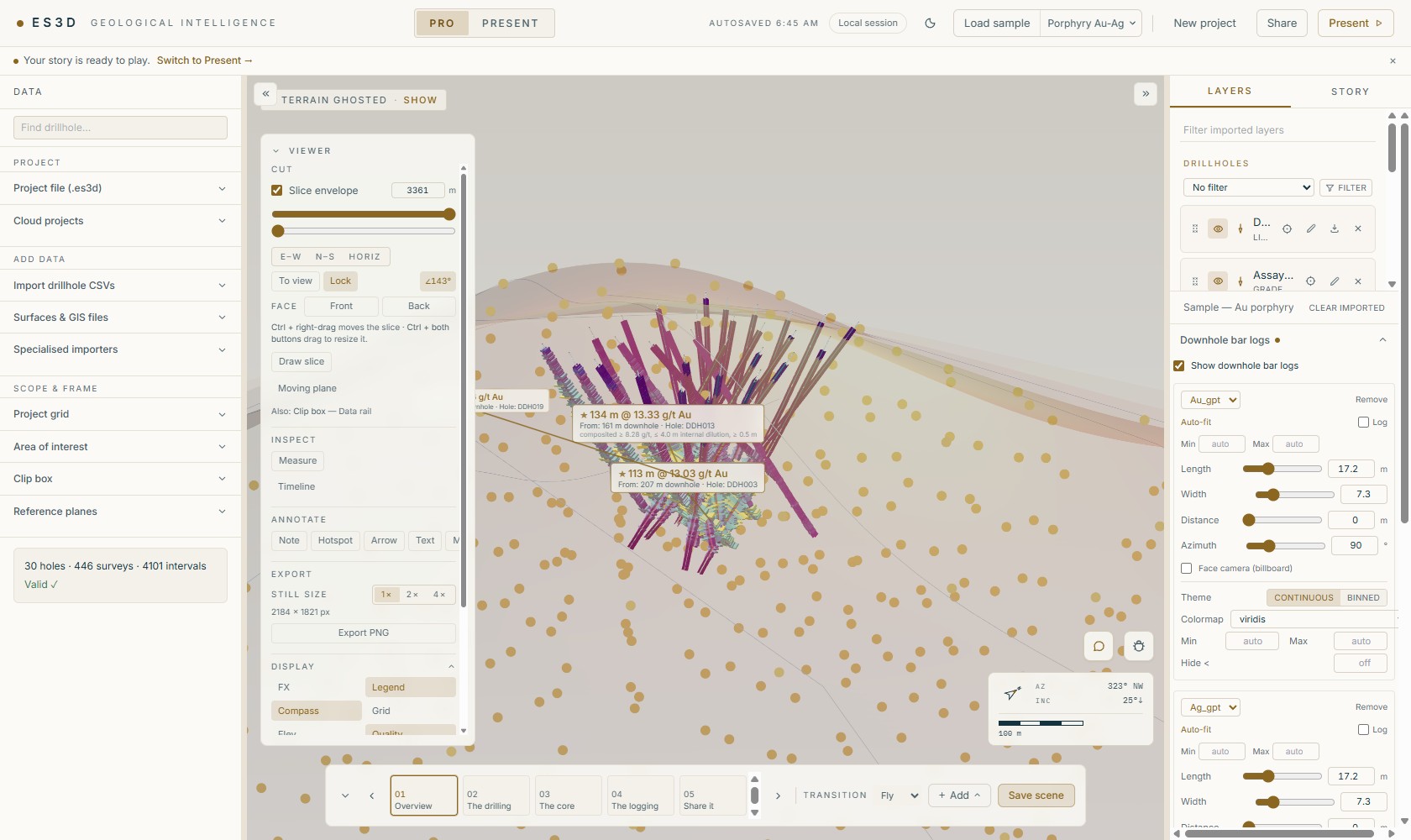
Layers tab → Downhole bar logs → Show downhole bar logs. Each configured log picks an element and an axis mode (Log / Auto-fit / min–max), with length, width, offset-from-trace, azimuth and billboard controls, and its own colour scale. + Add bar log puts several elements side by side. Values past the axis cap clamp and draw a gold rim — an over-range value never silently disappears.
Intercepts
The intercept engine finds the best grade×thickness runs and draws them as callouts with leader lines to the exact interval. Controls: Grade (minimum average), Width (m) (minimum width), Parts (top-N — view-aware, so it ranks the holes currently in view) and Includes (higher-grade sub-runs reported inside each intercept). Callout labels are draggable, and their style — text size and colour, box, corner radius, bold — is editable, with a Reset all callout label positions escape hatch.
Finding and filtering holes
- Hole search — the Find drillhole box at the top of the Data rail glides the camera to any hole ID (also via Ctrl+K).
- Drilling timeline — Viewer card → Inspect → Timeline: scrub or play the campaign hole by hole in drill order.
- Query filters — the Filter control on the drillholes group opens a named, savable filter: conditions on any column with operators and negation, Match all / any, an intercept condition (element / min grade / min width) and an explicit Show only these holes ID list. A filter scopes traces, collars, intervals, labels, the intercept list and section bar logs — and the matched-hole count is always shown. Filters persist in the project and per scene.
Several drillhole databases
Importing drillhole CSVs again adds a second database under Drillhole databases in the scene tree — styled independently, but coloured on the same ramps. The statistics panels grow a statistics source selector so a number is never ambiguous about which database it describes.
Statistics
- Project stats (Layers tab) — holes · total drilled metres · assay samples.
- Grade distribution — a histogram with log/linear x-axis, mean marker, and the top-cut cap line with its cap-impact readout (e.g. how many composites a 20 g/t cap touches).
Clearing the drill data
Layers tab → the foot of the Drillholes group → Clear drill data. Hiding a layer or removing a row from the scene tree is only a display decision — the holes stay loaded and the rows come back. This is the one control that actually drops them, so it confirms first and cannot be undone.
It takes the drillholes — every database, not just the active one — and everything derived from them: composites, downhole bar logs and intercepts, lithology legends, generated metal equivalents, planned holes, and the drill query filters and element colour ramps they were read through.
The workspace around them stands. Imported GIS layers, meshes and rasters are untouched, the project grid and Project CRS hold their registration, and the saved story keeps its scenes, cameras and narration — so you can clear one drilling database, import the next, and present the same story against it. Scene previews on the rail are deliberately dropped and regenerate as you revisit each scene: a baked photograph of drilling that no longer exists is exactly the kind of stale figure the app refuses to leave on screen (see Stories & sharing). A scene pinned to drill content replays without it rather than failing.